
With every passing day, month, and year comes a deeper understanding of our cultural heritage. It’s only fitting that today’s technology continues to lead the way in cultural heritage preservation and protection.
Moving Forward while Respecting the Past
We live in a world that stops for no one, evolving and changing before our very eyes. It’s an exciting period in history, making it easy for one to find themselves swept up by a relentless demand for progress. However, this pursuit can and should be completed in a manner that leaves the footprints left by those before us very much intact.
As we continuously develop and alter our landscape, we must recognize that many of these activities directly conflict with the past. We all have a duty to preserve and learn about our rich history while protecting and celebrating our heritage that’s waiting to be discovered.
As the nation’s leading cultural resources management (CRM) firm, this is a passion that we all share. PaleoWest is continuously strengthening its relationship and understanding of the past in a manner that can benefit the present.
The Increasing Role of Tech in CRM
It’s a simple message that requires little debate, with widespread support across the United States and further afield. Historically there have been problems in the practical implications for many businesses, from CRM firms with outdated processes to complex regulations slowing a project’s progress to a crawl. For many, protecting our cultural heritage can become an expensive inconvenience.
So what is the answer?
In witnessing its impact firsthand, we firmly believe in the ability of technology to offer solutions and overcome many of our industry’s traditional problems. Thanks to our spearheading innovation in the CRM field, advancements from world industries are a central pillar of our work across the United States and internationally. Our premier approach has ushered in sweeping innovations to traditional business practices and as a result, we proudly provide services that allow all parties to find fulfillment and enjoyment in the preservation process.
Our process and capabilities are managed by our highly skilled experts, ensuring we find every trace of our cultural heritage in the field. Covering vast expanses to locate items of interest with ease, we can now extract objects with outstanding care, preserving their condition with greater accuracy for future generations. For businesses, technology can improve efficiency at every stage by overcoming traditional hurdles, saving time and money.
What is in the PaleoWest Tech Cupboard?
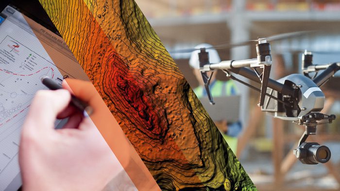
So, what kinds of innovative tech can you expect to find as part of PaleoWest projects nationwide? Keep reading as we introduce five of our favorite game-changing methods that help us protect our cultural heritage. You can also learn more about our entire fleet of technology here or our fully digital workflow, the PaleoWay, by clicking here.
Lidar
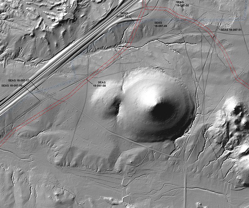
Next, let’s talk about Light Detection and Ranging, or LiDAR. LiDAR is widely accessible throughout the U.S. and abroad and often has objectives similar to aerial mapping and imaging.
LiDAR sensors send out laser light beams which are reflected back at different times by the surfaces in their path. As a result, the technology can pinpoint what you’re looking at with immense accuracy by collecting precise measurements of an object’s height and location.
At PaleoWest, we draw upon LiDAR elevation data to produce cultural resource sensitivity models, site maps, and historical trail maps, identifying features not visible on the ground.
We have used LiDAR across a diverse range of projects to identify highly sensitive landforms in southern Florida for prehistoric habitation sites and to identify tank tracks in the deserts of southern California. The latter was conducted in relation to a World War II Desert Training Center, with LiDAR being used to identify and measure preserved depressions created by the tank treads upon stable desert landforms. This enabled the identification of the tank type and maneuver pattern used.
Aerial Mapping
Believe it or not, the first aerial photograph was taken back in 1858 by a man named Gaspard Felix Tournachon. Aerial mapping is commonly used during the early stages of cultural heritage projects and uses Unmanned Aerial Vehicles (UAVs) to develop our understanding and interpretation of project sites in a way unattainable from the ground.
PaleoWest is the first CRM firm to be issued a Section 333 Exemption by the Federal Aviation Administration, and our aerial mapping capabilities include survey-grade maps, elevation models, and 3D reconstructions of subject sites, features, and landscapes. Because aerial mapping can easily cover vast areas of challenging terrain, the production of each deliverable is completed at a fraction of what traditional surveyors and pilots charge.
By mediating our relationship with the land, airborne technology such as this has transformed how we document, manage, and protect our unearthed cultural heritage, comprising one of many innovations that have become fundamental to our work here at PaleoWest.
3D Modeling
It is important to remember that the impact of technology in CRM is not only limited to the identification and recovery of culturally significant features. Innovations such as 3D modeling are crucial to enhancing their preservation and protection after their discovery.
At one time, access to features for further research may have been limited due to demand and fear of damage, but the emergence of 3D modeling enables museum pieces or project discoveries to be modeled digitally and replicated as many times as required. Consequently, both researchers and the general public can get even closer and more hands-on with their cultural heritage.
PaleoWest is proud to have recently reached agreements with tribes that harness this technology, resulting in 3D models of funerary offerings. This allows objects to be digitally preserved for scientific use before they are repatriated and reburied under provisions of the Native American Graves Protection and Repatriation Act.
Hohokam Buffware Jar
by PaleoWest on Sketchfab
Augmented Reality
The beauty of our cultural heritage is that it is everywhere to be found. By bringing the past back to life, augmented and virtual reality are emerging as two of the most engaging and exciting methods for preserving the past, from detailed and realistic interpretations of artifacts to immersive experiences that can guide users through locations from thousands of miles away.
As an incredible educational tool, AR and VR’s extensive range of capabilities is being leveraged to offer bespoke deliverables that mold outputs to meet the demands of any project. We at PaleoWest offer all of the following services to clients:
- 3D modeling hosted locally on mobile devices or via the internet
- 3D environment video flythroughs
- Interactive PDF documents with live frames that permit site touring
- Explorable immersive environments using goggles or screen-based interfaces
- In-field augmentation of reality with cultural elements
West Mancos Site Preservation Project – TS2
by PaleoWest on Sketchfab
Geographical Information Systems (GIS)
The spatial relationship between a cultural heritage site and its surrounding landscape can offer many insights into an area of interest. This is the job of GIS mapping.
GIS uses inputted data that is represented and studied in the form of maps. By separating “geo-referenced” data into layers, information sets can be analyzed individually or collectively. With this system, we can collect, combine, and store data sets about the environment that can initially appear independent of one another. GIS mapping ensures that public and private developers can decide on the best course of action with planning activities or projects upon sites of cultural significance. Apart from offering a lasting record of heritage sites and their features, GIS application has brought significant advancements to preservation and fieldwork practices and systematically evolved how we manage and develop land.
At PaleoWest, we also deploy GIS-based interactive websites in the form of Story Maps. These can employ 2D images, 3D models, and audio/video files to convey a captivating narrative through maps. Story Maps can be used to tour historic properties by drawing on a cellular phone’s internal GPS. Alternatively, they can be used to share a location’s history with a broader audience unable to travel to the site. For example, while completing the largest architectural history survey of its kind in Montgomery, Alabama, our team used Story Maps to create an immersive online tour of the city and its key sites, comprehensively documenting the pivotal role Montgomery played in shaping African American Civil Rights. Click here to read more about that project.

At PaleoWest, our expert consultants collaborate with state and federal agencies to complete projects that preserve, protect, and celebrate our shared cultural heritage, and can overcome any challenge to keep your project on track and within budget. For more information, use the form below to get in touch with us today!