Technology Solutions
INDUSTRY-LEADING TECHNOLOGY SOLUTIONS
Get unmatched quality and efficiencies with Chronicle Heritage technology solutions.
Our workflow is fully digital, from data collection through to management and compliance. From aerial mapping, 3D modeling, and GIS mapping to augmented and virtual reality and many other services, we’ve been passing on the time and cost efficiencies to our clients for years.
Our cutting-edge use of technology solutions is faster and more accurate, produces report-ready data from the get-go, and is pre-programmed to interpret and include your project’s compliance requirements. Get in touch with us – we’d love to learn more about your project.
Aerial Mapping
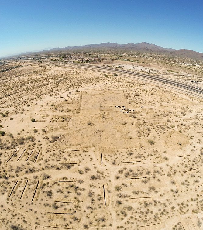
Chronicle Heritage routinely uses aerial mapping in our projects because it is an accurate and efficient way to capture detailed and comprehensive data from a vast area.
We have a fleet of fixed-wing and multi-rotor unmanned aerial vehicles (UAVs) for the purposes of low-altitude aerial mapping. Tackling the most challenging terrain with ease, our UAVs produce survey-grade maps, elevation models, and 3D reconstructions at a fraction of the cost of traditional methods.
Aerial mapping is particularly useful in areas where we need to treat cultural and/or biological resources with care and where terrain is inaccessible.
3D Modeling
Chronicle Heritage’s use of 3D modeling has made a significant contribution to the preservation of our shared story by documenting, analyzing, restoring, and educating others. Our 3D modeling is completely noninvasive; we use LiDAR and nondestructive photogrammetry.
Individual objects from project or museum collections can be quickly modeled for digital preservation and 3D replica printing. For project sites under threat from looting or other kinds of destruction, 3D modeling provides a precise digital record to assess the condition of a resource and, if necessary, to even reconstruct it in the future.
GIS Mapping
Chronicle Heritage provides GIS mapping services that will help you make informed decisions about your land development project.
GIS captures spatial information about a specific location and identifies entities and locates features. Using this data, our team is able to create highly accurate maps that are far superior to hand-drawn ones.
Enhanced Artifact Illustration
Chronicle Heritage provides enhanced artifact illustration services using tools that are able to achieve a level of detail that was previously only possible with hand-drawn illustrations.
Many of our projects require us to photograph artifacts and their features as part of the preservation process. Gathered in the field or under controlled lab settings, our high-resolution images are used alongside sophisticated laser scanning devices to build 3D models of artifacts in incredible detail. Our team draws upon 3D applications and enhanced visualization tools, both crucial to maintaining cultural resources, to ensure that objects recovered from a project are preserved correctly.
Augmented and Virtual Reality
The beauty of Chronicle Heritage’s augmented and virtual reality services is that we’re able to create immersive experiences that bring cultural heritage resources to life for a far-reaching audience.
This service can take many forms, depending on what your project requires: interactive 3D models hosted locally or on a mobile device; video flythroughs of 3D environments; interactive PDF documents with live frames that permit touring of a site; immersive environments using a screen-based interface or goggles; or, in-field augmentation of reality with cultural elements. The applications really are endless.
Enhanced Feature Mapping
Enhanced feature mapping is a service provided by Chronicle Heritage that captures the features of a landscape or object from every angle so that you have accurate information for your project workflow.
The mapping of features in the field is usually a time-consuming process. This is especially true when tackling complex stone features, bone beds, rock art panels, and other features where highly accurate measurements are essential. Chronicle Heritage uses photogrammetry to expedite this process in the field, with enhanced feature mapping to analyze features and produce detailed, full-scale 3D models. Outside the field, these models are utilized to calculate measurements of features, like bone lengths and robusticity, sciatic notch size, and more.
LiDAR
Chronicle Heritage uses LiDAR to cover large areas from the air, which simultaneously reduces ground-time and gives highly accurate information about any culturally significant sites in the landscape.
LiDAR (light detection and ranging) is a remote sensing method that uses near-infrared, visible light, or ultraviolet light to measure the distance between an object and a sensor. Our team regularly uses technology solutions like this to produce models of cultural resources, site maps, historic trail maps, and to identify features not visible from the ground.
Story Maps
Our team at Chronicle Heritage can build story maps and virtual tours of your cultural resource. Story maps are an immersive way to engage people who want to learn about a location’s history, and do so remotely.
This technology can also act as a mitigation measure; in one example, story maps were recommended by the Florida and Georgia State Historic Preservation Offices instead of HABS documentation.
Both these tools offer remote access and enhance interpretive learning while documenting and preserving the resource.
Cultural Resource and Heritage Management Solutions for Major Projects
Challenging projects enliven us – so bring us your project headache. We’ll partner with you all the way. And, we’ll start by bundling our services so you meet your milestones efficiently.
Marana Center Data Recovery Project
This project was the first large-scale, all-digital archaeological excavation in the United States. Working against a deadline for Vintage Partners in Tucson, Arizona, we leveraged our technology to cut the fieldwork component from 18 weeks to just 10. And, because of our digital workflow with compliance parameters pre-programmed, we delivered the clearance report the day after we finished the fieldwork. This turnaround meant we got the federal agency’s approval within a remarkable 30 days.

Ask Chronicle Heritage
about the services we offer in your sector.
